CHURCH HISTORY MAPS
THE MISSOURI, ILLINOIS, AND IOWA AREA OF THE USA
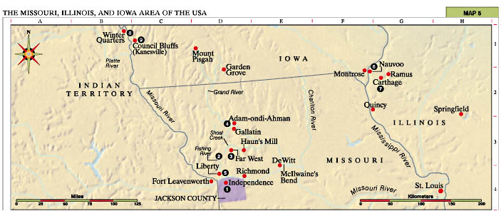
1. Independence Identified as the center place of Zion (see D&C 57:3). A temple site was
dedicated on 3 August 1831. The Saints were driven from here in 1833.
2. Fishing River Joseph Smith and Zion’s Camp traveled from Kirtland,
Ohio, to Missouri in 1834 to restore the Jackson County Saints to their land. D&C 105 was revealed on the banks of
this river.
3. Far West This was the largest Mormon settlement in Missouri. A site
for a temple was dedicated at this location (see D&C 115). On 8 July 1838, the Quorum
of the Twelve Apostles received a call from the Lord to serve missions in the
British Isles (see D&C 118).
4. Adam-ondi-Ahman The Lord identified this place in upper Missouri as
the site where a future great gathering will take place when Jesus Christ comes
to meet with Adam and his righteous posterity and receive keys (see D&C 78:15; 107:53-57; 116).
5. Liberty Jail Joseph Smith and others were falsely imprisoned here
from December 1838 to April 1839. In the midst of troubled times for the
Church, Joseph called on the Lord for direction and received D&C 121-23.
6. Nauvoo Located on the Mississippi River, this area was the gathering
place for the Saints from 1839 through 1846. Here a temple was built, and
ordinances such as baptism for the dead, the endowment, and the sealing of
families began. Here the Relief Society was organized in 1842. Revelations
received include D&C 124-29.
7. Carthage Here the Prophet Joseph Smith and his brother Hyrum were
martyred on 27 June 1844 (see D&C 135).
8. Winter Quarters The headquarters settlement for the Saints (1846-48)
en route to the Salt Lake Valley. The Camp of Israel was organized for the
westward journey (see D&C 136).
9. Council Bluffs (Kanesville) The First Presidency was sustained here
on 27 December 1847, with Brigham Young as President.